Saturday, January 28, 2012

The Earthquake Fault and Inyo Craters

 
Okay, so according to the poster-board it's not really a fault, it's a fissure. Regardless, it's still pretty impressive.

If you take the Minaret Road out of Mammoth towards the ski area and pass the Mammoth Scenic Loop Road on your right, the very next right is the road up to the parking lot for the Earthquake Fault.
 
You can walk around here and explore the fault/fissure. It's right there, not even a walk. In fact, you can even see the fault from the road as you drive over it a little further along where the Minaret Road crosses it. But it is worth getting out and having a gander at it.
 I particularly liked how this tree grew out of the side of the fault at right angles!
But that is just your warm up to the day's hiking. Hop back in the car and head back towards Mammoth and turn left onto the Mammoth Loop Road. Keep an eye out for signs to the Inyo Craters. The road will be on your left-hand side. If you reach the US395 you've gone to far and will need to double back and clean your specs!

We had to park at the start of the road that leads to the parking lot as the road was covered in a two-inch thick layer of ice.  During the summer tourists will be able to drive all but the last mile up to the craters. It only added about 2-3 miles round trip to our hike and was very pleasant.

Inyo craters are three fairly recent (within the last 600 years) volcano craters formed from a  chain of eruptions. Here's the low down!
Like the fault, we had the place to ourselves. I'd imagine that in the summer these sights are thronged - unless of course everyone is at the Devil's Postpile or swanning around Yosemite! (See my previous posts on this...)

If I didn't know I was looking for volcano craters I's have thought the first one was an abandoned quarry, frozen water and all.
The edge looked precarious with soft crumbling rock and you can see where the  first fence wasn't quite far enough back. I hope they didn't discover this the hard way! One less tourist....
The second crater was slightly bigger. If this was the Goldilocks story it would be the "just right" one! However, this ain't no fairy tale. This one seemed to lack a body of water, though it was hard to see down into the bottom with the trees in the way.
That's Mammoth Mountain in the background in the picture below.
So we decided to summit Deer Mountain which was, unbeknownst to us crater number three. Where we thought the third crater was is anyone's guess but a crater and a mountain are, to my mind, totally different things - one goes up in a point and the other goes down in a point!

Deer Mounatin went up quite steeply - check out the gradient using the trees as the vertical upright.
We could see the summit off in the blue yonder and headed straight up, pretty much forgetting about any trail there may have been. The one we'd been on had sort of petered out.
 
The top was all badlands, soft, crumbly soil, and steep. It was like trying to walk up a pile of brown sugar that had been in the cupboard a little too long.
I was looking forward to sitting down on the top but when we got there, it was a craters edge with a vicious drop on the other side. I was scared up there and we didn't hang around for fear that the land might cave beneath us.
We seem to have a thing with craters in this part of the world. Several years ago we took off exploring around Ubehebe Crater in Death Valley with no water. I was dressed in a pink mini skirt, tank top and no sun screen. Not exactly hiking gear. And definitely not for hiking in Death Valley. (Surely the name might be some sort of deterrent!)
Did I mention the temperature was 100F+ ?
We'd walked around about what we thought was a third of that crater and decided we could circumnavigate it. 
Can you see me in the distance, top right? After an two hours we were still walking. We could see our car across the crater , a mere spec in the distance and we were getting pretty thirsty. As it turned out we got back to the car without any drama, but all it would have taken was one one thing to go wrong - a sprained ankle, a startled rattle snake and it would have been a whole different story...

Thankfully someone was watching over us - both times!

Byddi Lee

Thursday, January 19, 2012

Minarets Vista and water in three states

The arrival of the rain today allows me to sit inside and watch God water my plants for me. It also gives me a chance to catch up on housework writing more posts about our ski-turned-hiking holiday.

So, after two lovely days of skiing we decided to swap our skis for hiking boots - drastically more comfy footwear to be sure!

The internet is frustratingly tuned into either winter ideas or summer ideas for Mammoth and its surroundings. The Red Meadows and Devils Postpile (an inland version of our Giants Causeway - stacks of hexagonal rocks that crystallized slowly from magma) are the main ones that search engines throw out, but the road to there is closed to traffic during the winter and only accessible in the summer via a bus. Cars are simply not allowed into that valley. The braver and more hardy could walk the 7 or 8 miles to the trail heads, but we were warned against doing that. Apparently the November snow is still lying in the valley.

In the end we had to get our information the old fashioned way. We drove to the tourist information office. Finding the actual address for it online was a tedious task given that the internet for the room was patchy, but in the end we got it. We managed to talk to a real human being, which helped immensely seeing that I was getting dizzy on the merri-go-round of
"Where can we hike?"
"Devils Post pile, but the roads are closed"
"So where can we hike?'

We got a newletter, on real "newspaper" paper and it had great deal more information for us. This information is probably online but to find it you'd have to ask the right questions or at least type in the name of a feature like "Minarets Vista" to get some snippet of information embedded in a vast array of info on The Devils Post pile. If you don't know first where to hike then all you get is Devil's Postpile. See the problem?

I've noticed this "tourism tunnel vision" before. For example, even though there are lots of gorgeous places to visit in the Sierra's, Yosemite is pushed to the forefront every time - forget the rest! And Yosemite IS fabulous, but there are other things to see in California. Just like there are other things to see besides the Devils Postpile in Mammoth.

So we persevered. We established what was feasible to do in the conditions we had and planned to hike three days and ski on the last day.

Minarets Vista is a 3 mile round trip from the Mammoth Inn. Not a huge distance for our first day hiking but it was at an elevation of 9000ft.

And the road was covered in snow most of the way.
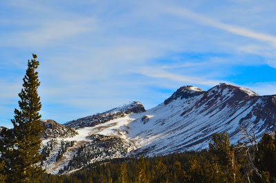
It was actually a cross-country ski trail but the skiers had to turn back where the snow stopped. But we could keep going. And, oh boy, was the view worth it!
At this stage we were agonizing over the decision to walk the 8 miles to go see the Devils Postpile (and then there was the 8 miles back too.) Should we get up early the next day and try it, or would there be too much snow?
Would it be foolish and dangerous and would we end up on the evening news in an embarrassing rescue scenario?

The road down from this point looked clear and we walked to the corner to see how it looked beyond that - the same.
It was tempting to keep going but my gut reaction said no. Plus, I wasn't sure what was happening with bears at this time of the year, especially with the funky winter conditions we were having. The 8 miles uphill was not welcoming either. Too late to go for it today we turned back towards Mammoth Mountain.

Can you see how it got its name ? I think it looks like a big slouchy mammoth.
 
Still intreged by getting to the Devils Postpile we decided to see if we could drive to the trailhead for Mammoth Pass and get to it from there. Every single resort employee and local we talked to said that it couldn't be reached... but still... with this lack of snow...

We only got as far as Twin Lakes, which were completely frozen.
The road was clear of snow but closed. It was a few miles to even get to the start of the pass from here. It was not an option, it seemed. So we decided that we'd use the remaining daylight and to go see the hot springs at Hot Creek, and we left the frozen lakes behind.
Hot Creek gets its name from the geothermally heated water which joined the creek.
Once upon a time people were allowed to bath here, but seismic activity increased on the mid 1990s and some people were badly burnt, some even died as a result of flash temperature increases.
There are "safe" paths so you can explore the area. Pretty cool at sunset as the air temperature drops and the steam rises dramatically from the pools and underground vents.
It must have been amazing for the native people to find an area like this, especially in the winter where they must have been able to put it to some use keeping warm.
I know these things cost money and impact the environment, but I'd love to see an interpretive center here complete with bathing facilities.  It wasn't until I got back home and was fact-checking for this blog that I found out about places where you could get into the spring's water in baths. Again, a big secret and hard to get information on in the village and resort!

There is a fish hatchery here. It may be of interest to people who like fishing (if they let you fish).

But despite our frustrations at feeling like we were not  "allowed" to do things due to a conspiracy of withheld information (or just pure dumbness at finding it out on our behalf) we headed for our hotel looking forward to soaking in the bath. At least I could find the hot tap.

As we left the dirt road that leads to the Hot Creek we spotted these locals. Cute!

More Mammoth hiking to come...

Byddi Lee

Wednesday, January 18, 2012

'S no joke

We are promised rain tomorrow. It's a little late for us though, as we've already trekked all the way to Mammoth and back last week to go skiing. Having prepaid for the hotel and booked the days of work, we couldn't really sit tight and wait for the snow.

Usually during the winter the mountain passes across the Sierras are closed, so we had our route planned through Bakersfield, with an over night stop (prepaid through Expedia) there to break up the 8-9 hr trip around the southern end of the Sierra Nevadas.

Seeing how it hasn't rained (which translates to snow in the mountains) since November, all the passes were open and the hills and mountain were bare but for a few frosty tipped peaks.

Refusing to be a "glass-half-empty" gal, I usually shove someone in the direction of the bar, or when I'm not being literal, I make the best of what comes my way.

Bakersfield seems to have a reputation for having nothing going on and is viewed as just a place to stay the night before moving on to bigger and better things. I'm not convinced that is fair, but since we did exactly what I described in the previous sentence, I don't have a great deal of evidence to contradict that. I was surprised by the presence of those nodding oil drilling contraptions everywhere. Bakersfield has oil fields (as opposed to fields of bakers?!)

An unpleasant chemical odor pervaded the air and I was glad to be leaving that behind the next morning. It was good to be on the open road, this time in daylight, having left San Jose after sundown the day before.
We drove through a swirling patchy fog out of Bakersfield taking a more northerly pass than we'd at first planned that took us past Lake Isabella. It didn't take long for the sun to burn the mist off, giving us gorgeous vistas of the southern tip of the Sierra Range where it spread into the Mojave Desert. I can look at deserts the way other people can gaze over oceans and be soothed, awestruck and scared of its dangers all in equal measure.

We didn't stop to take photos as we just wanted to get to Mammoth. But as we saw the moon rise over the desert (behind those mountains lay Death Valley) we had to stop for this shot.
 And about ten minutes later we stopped again for this one! Would we ever get to Mammoth?
Night had fallen by the time we pulled up at the Mammoth Mountain Inn, our slope-side home for the next week. Ski-in ski-out if you didn't count walking across the bone dry car park! During check-in we learned that there was man-made snow for skiing on and that enough of the mountain was open for the ski resort to feel justified in charging the full cost of the lift ticket. Trying to focus on being happy to be on vacation and away from the world for a week, I reconciled myself to the fact that this was not going to solely a ski trip.

The room was comfortable, the flat screen TV huge and I had Stephen King's "Under the Dome" - 1000 plus pages of thrilling story telling from one of my favor authors. Having a great holiday was not up for negotiation!

The next day dawned with that headache inducing-glare that comes from sunlight bouncing off snow. (Snow? Where did that come from?) Brilliant blue skies and not a cloud in sight. But the lifts were running and did I mention there was snow?

The hill was quiet. We collected our skis from the ski valet (I know! Imagine not having to carry your own skis...) and went for lunch! Well, what was the hurry? Especially when you can buy a cheaper half day lift pass at 12.30pm AND spend the morning in bed with Stephen King! My husband was thrilled - he's not a morning person.

The person at the information kiosk happened to mention two interesting things. 
1 - Afternoon ski lessons included the price of the lift pass. A good deal at $90 for a two hr lesson and pass (which costs $67 for the afternoon), 
and 2 - We'd have the instructor to ourselves as the place was empty. A private lesson for $23 each.

But not so fast. At the ticket desk we were informed that it was beginner lessons only for the afternoon. Having worked as a level one instructor many moons ago, I wanted to make sure we got at least a level two or higher instructor, so I chatted to one of the very friendly and accomodating ski school managers and he set us up with a great instructor for the same price as the beginner lessons.

We had a great afternoon swanning around the slopes. I was very impressed with the quality of the man-made snow. The temperature was low enough to make as much of it as they could and it didn't melt during the day either. It stayed crisp and ski-able all day long. I've skied in much worse snow.
Notice how bare the surrounding hills are. Nevertheless, it was great conditions for being out on the mountain. No shivering on chair lifts, the temperature was comfortable and we had the place to ourselves. Our instructors gave us some great tips and, for me, reminders about bad habits I'd slid back into. My husband, who has only ever had one ski instructor - me, made great improvements. I could not decide whether to be happy about that or not!

The following day we spent the afternoon skiing all that was open. The top was only open for sight seeing so we did mostly blues and whatever blacks we could find that had snow.

It was evident that our ski holiday would have to mutate into a hiking trip. An idea we both embraced. It was perfect hiking weather. A trip to the tourist information office, loaded down with pamphlets and trail guides and we headed back to the room to plan the surprise "summer vacation" part of our trip we were lucky to be able to take advantage of.

The food in Mammoth is nothing to write home about, (we're probaby spoiled by living in the Bay Area) but you can feast your eyes all day on the heart-achingly gorgeous scenery caused both by ancient ice ages and more recently volcanic activity.

At the end of Day Two of the ski trip I snuggled up in bed with Stephen King and looked forward to exploring the Mammoth area of the Sierras. 

More on this soon!

Byddi Lee


Sunday, January 8, 2012

I never promised you a rose garden

When Master Gardeners offered its members a rose pruning workshop at the San Jose Heritage Rose Garden, I jumped at the opportunity.  I may only have three roses myself, but I wanted to be sure that if my clients had roses that I'd be getting it right. 

Roses seem to have a reputation for being delicate, pernickety plants that gardeners have to coax along and pander to. Don't be fooled. Sure, they can have their fair share of diseases, but when it comes to low water, heat tolerance and frost hardiness they are tough little garden soldiers.

Back home, when it came to pruning roses I pulled no punches. Those babies got hacked to within inches (usually between 4 and 8) of their lives and they always came back with full astonishing bloom. 

But it doesn't have to be like that here. John R, the MG who showed me how its done in the Golden State, was a fabulous teacher. I came away with at least three new things that I either didn't know or that changed the way I'd previously pruned. To me that's a hugely successful workshop.

So here's "Pruning Roses in Santa Clara County 101"

1  Don protective clothing - leather gloves, denim shirt and a hat.

2  Bypass pruners and lopers are the tools you will need.

3  Begin at the base of the rose bush. Clear away leaf-litter and identify the graft union. This is a bulbous scarred area, usually near the base, where the rose you want is grafted to its root stock. Anything growing below this a sucker and you don't want it.

4 Tear away any suckers. Previously, I'd been clipping off my suckers but, as John pointed out, this left behind growing material, so I always had a recurrence of these suckers. Ripping them out takes more away and helps prevent regrowth. So far we haven't used those pruners or lopers yet.

5 Next, and this I found hard at first, defoliate the bush. Take off every leaf you see.
This is all last years leaves and will contribute little by way of photosynthesis, especially if the leaves are diseased in any way. Removing them tricks the rose bush into a sense of dormancy, promotes new growth and helps prevents spread of rust and black spot.

6  Before we pick up the pruners, identify the growing points. They are nubs of tissue along the stem, more fleshy than the thorns and not prickly. You'll also find them at the base of the petioles of the leaves you removed.
 
In the above photo the thorns are beige and the growing points are purple.

7  Remove dead branches, anything less than a pencil thickness (that was another hint from John) and any branches crossing or otherwise growing the wrong way. Some of this is also subject to aesthetics. If you have two bushes growing close to each other, you want to prune them so that you can separate them out. In the above photo, I took out one of those crossing branches. This opens up the middle and helps prevent disease. It reminded me of the rules for fruit tree pruning.

8  Choose growing points that point in the direction you want the bush to grow - usually up- and outwards.


9 Leave about an inch of stem between the cut and the growing tip. Here's one I did a little too close last year. The tip may not grow.

10  John reckons that the more you leave, the more food storage the plant has for regrowth. This is where I stopped.
 
There is also a really good section on roses at the MG website. 

Another Master Garden told me that if you ask 10 rose experts how to prune you will be told 15 different ideal ways how to do it!

Bottom line - don't be afraid of "hurting" your rose. Chances are anything you do at this stage will benefit rather than stunt your rose garden. As John Hammond said in that great work of literature Jurassic Park, "And if we could only step aside and trust in nature, life will find a way. "

If it works for extinct dinosaurs, I'm sure it will apply to half dead looking roses!

Byddi Lee